


By Jon Johnson

MOUNT GRAHAM – The Frye Fire on Mount Graham has intensified as previously wet fuels have dried out due to the loss of humidity during the beginning of a heat wave that will only intensify the fire in the week to come.
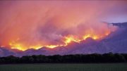
The result was a big growth Thursday night, which brought forth some stunning pictures from our readers. The fire is spreading down on both its eastern flank, toward Frye Mesa, and its western flank in the Ash Creek drainage and has now surpassed 1,000 acres.
Contributed Photo/Courtesy Katie Cluff
The Gila/Las Cruces Type 3 Management Team remains in charge of the fire, and firefighters are continuing their efforts to build and maintain fire lines to protect assets on the mountain, including cabins and the Mount Graham International Observatory (MGIO). The only direct fire suppression effort is helicopter drops in the Ash Creek drainage area to attempt to slow the fire’s progression up the hill so fire lines at the top are cleared out and in place to do burnout operations.
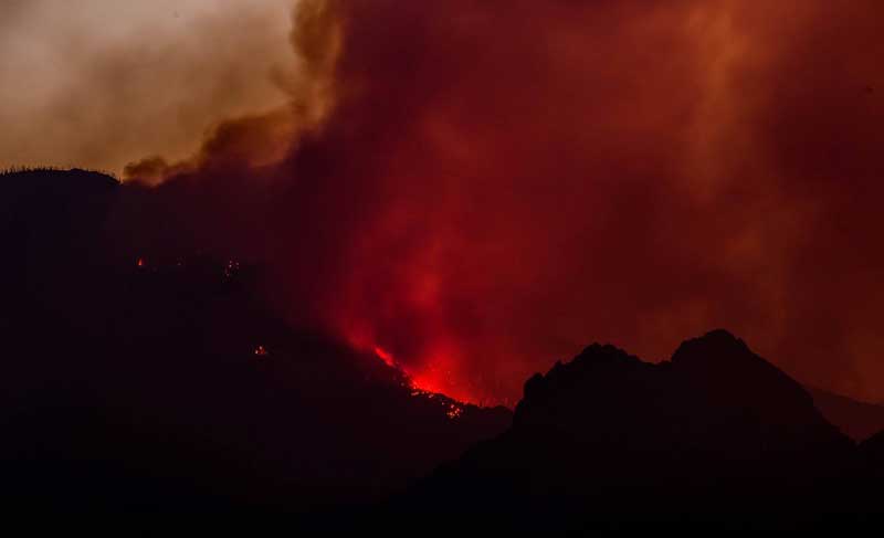
Jon Johnson Photo/Gila Valley Central: Smoke from the Frye Fire turns color during Thursday’s sunset.
Gila/Las Cruces Type 3 Management Team Public Information Officer Nick Smokovich said while the fire’s activity has increased it is still within the parameters of how the agencies have decided to battle it. He said the only difference is the intensity of the burning due to the weather change.
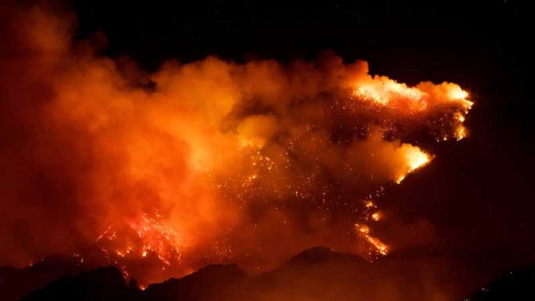
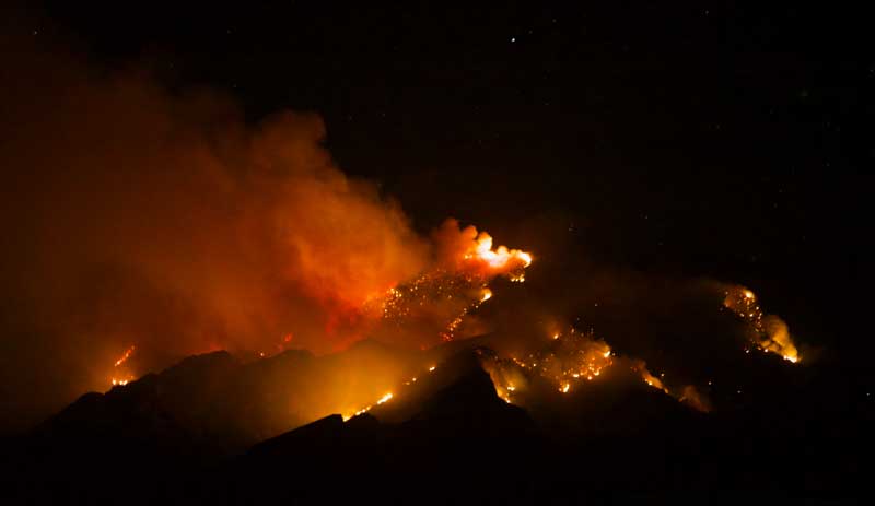
Contributed Photo/Courtesy Paul Schulz: In this picture taken early Thursday night, the fire looks like a volcano spewed lava.
“The main change is the weather,” Smokovich said. “We were having cool, nighttime temperatures up there and the relative humidities were recovering at night.”
With a new high-pressure system moved in, however, relative humidity has dropped to single digits, even as low as 2 percent. And what was previously a very wet area that caused a lot of slow burning and white smoke has now changed.
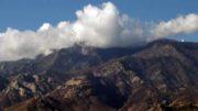
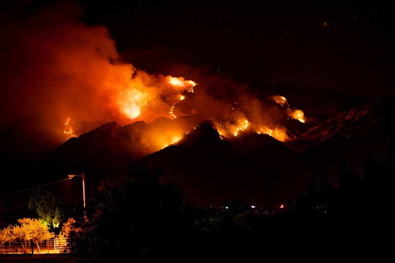
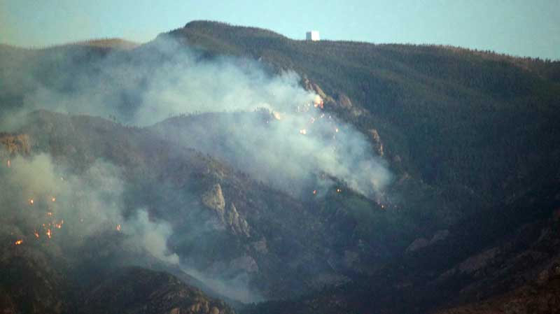
Jon Johnson Photo/Gila Valley Central: This picture shows the overall spread of the fire early Thursday night. Low humidity has aided the spread and intensified the burning of previously wet fuel.
“The pure science of it is those fuels are drying out faster and faster each day,” Smokovich said. “Instead of just smoldering logs, now they’re being actively consumed . . . It’s the difference between burning wet grass that just smokes and tinder, dry crunchy stuff that just ignites . . . It’s only going to continue to become drier and as far as the activity of the fire, it’s only going to keep increasing.”
Contributed Photo/Courtesy Coronado Fire District
The fire hasn’t crossed any containment lines and hasn’t grown beyond predictions, so the same strategy is to continue suppression efforts by building the perimeter lines on top of the mountain along Forest Service Road 366 that goes by the Columbine cabins, Bible Camp and the observatory. They are also continuing to build west toward Riggs Lake, where there is a stand of Aspen that burns at a lower intensity and is a better spot to fight the fire.
The fire is burning up Ash Creek Canyon toward the cabins and other structures, and fire crews continue to make helicopter drops on it to “check” it as best as they can to slow its progression. However, Smokovich said air support won’t be able to knock out the fire up there due to the trees and other fuels its burning and they will make their stand with burnout operations at their fire lines if it comes to that.
“No amount of air support is going to change the burning of this fire,” Smokovich said. “There’s too much heavy fuels to expect air drops alone, whether they be from a helicopter or from aircraft or anything else, to put a stop to the fire somehow on mid slope on this mountain.”

Contributed Photo/Courtesy Coronado Fire District
The Frye Fire is still burning within the 2004 Nuttall Complex burn scar, which scorched roughly 30,000 acres and threatened the multimillion dollar MGIO.
“At some point, when it’s the appropriate time, they’ve already identified a management action point where they will burn off those preparations and stop the fire spread at the top of the hill,” Smokovich said.
A smaller contingency of crews are building fire lines around ranches on the lower elevations on state trust land and private property, but when the fire gets there drops from above will be more effective.
“There’s a change in vegetation type once it goes down to a certain elevation where there just isn’t the fuel to keep it going, and with a little bit of aircraft support, if need be, they can easily check that spread,” Smokovich said.
The Frye Fire began Wednesday, June 7 at about 2:45 p.m. by lighting. Air support was not available at the time of the fire due to higher-priority fires around the state and the decision was made not to risk firefighter lives with only a small 8-person crew available to attempt to insert personnel into the highly-dangerous terrain. The area is chock-full of downed logs, standing dead trees and rough terrain that makes fighting the fire on the ground extremely difficult.
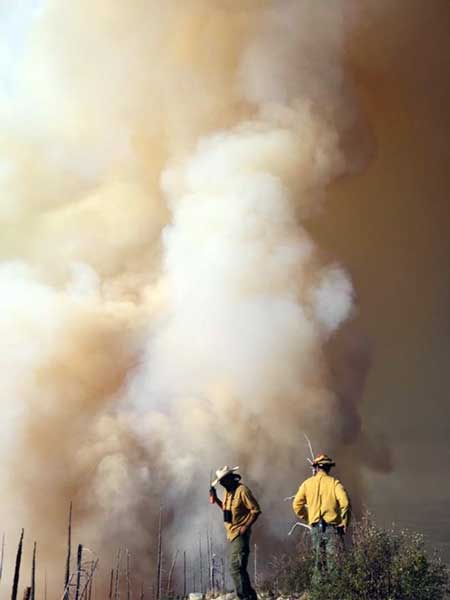
Jon Johnson Photo/Gila Valley Central: Firefighters continue line preparation for a burnout at the top of the hill to prevent the Frye Fire from progressing toward cabins and the MGIO.
A community meeting will be held at the Graham County Services Building at 921 W. Thatcher Blvd. in Safford on Friday at 7 p.m.